With its lovely mountain ridges and wide valleys, the Lower Galilee attracts travelers all year long. But by February, when the hills fill with colorful flowers and the streams are gushing with water, this area becomes a popular destination for even more visitors than normal.
Almost anywhere you go in the region, you’ll find enjoyable hikes. There are easy trails as well as more challenging ones for more experienced hikers. This week, I’d like to describe one of my all-time favorites: Nahal Tavor.
Nahal Tavor is one of the best places in the country to go for an outing in nature. It has pristine streams, beautiful seasonal flowers, lots of greenery and nice walking trails. If you’re lucky, you might even catch a glimpse of some animals that live in the region. Nahal Tavor is a great area to explore with kids who love getting “lost” along the many trails.
I love walking along Nahal Tavor any time of the year, but in the winter it’s especially exciting since the river is gushing with winter rainwater, and flowers such as the autumn squill and Steven’s meadow saffron abound.
While this area is an extremely popular place for Israelis to go hiking, it also holds great significance for Christian pilgrims, who come to visit the Holy Land from all over the world. They are keen to visit the Franciscan Church of the Transfiguration and the monastery, both of which are located at the top of Mount Tabor. But even if you’re not interested in visiting Christian sites, it’s still worth coming to the area just to experience the gorgeous scenery and nature.
NOW, BACK to the hike along the stream, which is also known by its Arabic name, Wadi al-Bira. The stream begins near Nazareth and then passes through Mount Tabor before joining the Jordan River. In addition to functioning as an integral source of water for Galilee residents, Nahal Tavor is a major water source for many deer and other animals that live in the region.
Nahal Tavor is a perennial stream, which means it flows all year round, not just following the winter rains. This is no minor feat, considering the years-long drought and the significant amount of water that is pumped out for local consumption. Despite the dry years, the stream also accumulates water from a number springs, including Ein Ze’ev, Ein Rechesh and Ein Shahal, which help keep the stream running even on hot summer days.
One of my favorite trails in the area is a circular path that starts near Kibbutz Gazit. Finding the starting point is really easy, and you’ll see the red trail markers right there in the parking area. Take this dirt path until you reach a crossroads with the black trail markers. From that point, continue along the black path for a few minutes, and then turn right onto the path with the blue trail markers, which will take you right down to the bank of the stream.
From this point, the path continues right alongside Nahal Tavor, and since there are lots of lush, green bushes and trees, it’s a much more shaded and dark area. The density of the greenery shades us from the hot sun in the summer, but also protects us from the cold winds in the wintertime.
Continue along the shaded path for another kilometer, where you’ll see plenty of white acacia trees, one of the most common trees in the Galilee. At this point, you’ll have reached a lookout point from which you can look out over the Lower Galilee. This is a great spot to stop for a picnic before continuing on.
The next section of the trail includes a relatively steep descent, but don’t worry – it looks a lot more daunting than it actually is, especially if it’s your first time here.
Within a few minutes, you’ll have reached Tel Rechesh, which has undergone extensive excavations by Israeli and Japanese archaeologists. The ancient city of Anaharat is believed to have been located on this spot, a city that was mentioned in the Book of Joshua as one of the cities that the Tribe of Yissachar settled in. An Egyptian victory monument was found during excavations, which serves as proof that the city was an important locale during ancient times.
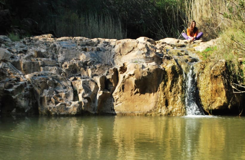
The next section of the trail continues alongside the stream. After about two kilometers, you will reach a canyon made out of basalt stone. There, you’ll find pools of water and a waterfall that crashes down onto the basalt stone. I recommend stopping here for a break and dipping your feet in the water, even if it’s pretty cold. But if you’re there with kids, I wouldn’t let them put more than their feet in, since the water isn’t so clean. It is best to point out the beautiful scenery and just move on quickly.
One more interesting point of interest you’ll see on the Nahal Tavor trail is the remains of an ancient flour mill. You can’t miss it, since there’s a huge palm tree right next to it, where lots of people like to stop for a selfie. This is the last stop. From here you will follow the red trail, which will take you back to the parking area where you left your car.
Type of trail: Circular.
Level of difficulty: Medium-hard.
Directions: Take road 65 and then, at gazit junction, turn toward kibbutz gazit. Enter the kibbutz at the main entrance and then exit from the back entrance. Drive along the dirt road until you reach the beginning of the trail.
Translated by Hannah Hochner.
